
Category Archives: QuickPost

Trail Post Project – New P.O. Box!
The Trail Post Project
I am a big fan of hand written mail. In an attempt to revitalize this age old past time (which is quickly being lost to web-based communications) I’d like to reboot a post card project. Send in post cards with words of inspiration to get others outside and enjoying nature, and I will post selected post cards to the website.
Project Goal: The goal is to inspire others to hit the trail and see new places! Nature can be a much better medication than the couch.
How you get involved: Tell me about yourself! Send in post cards with positive words of inspiration for others to get outside. Tell me your story, tell me about your favorite adventure, tell me what makes you keep climbing, hiking, kayaking, or however you move through nature. Send in your wishes for friends or family to get outside, tell me about an adventure you hope to do in the future. Post your real name, trail name, or leave it anonymous, anything goes, just be creative!
The Re-Post: I will select a few post cards every month to be displayed on the Trail Post tab of the GoatManMike.com home page. I look forward to receiving your trail posts!
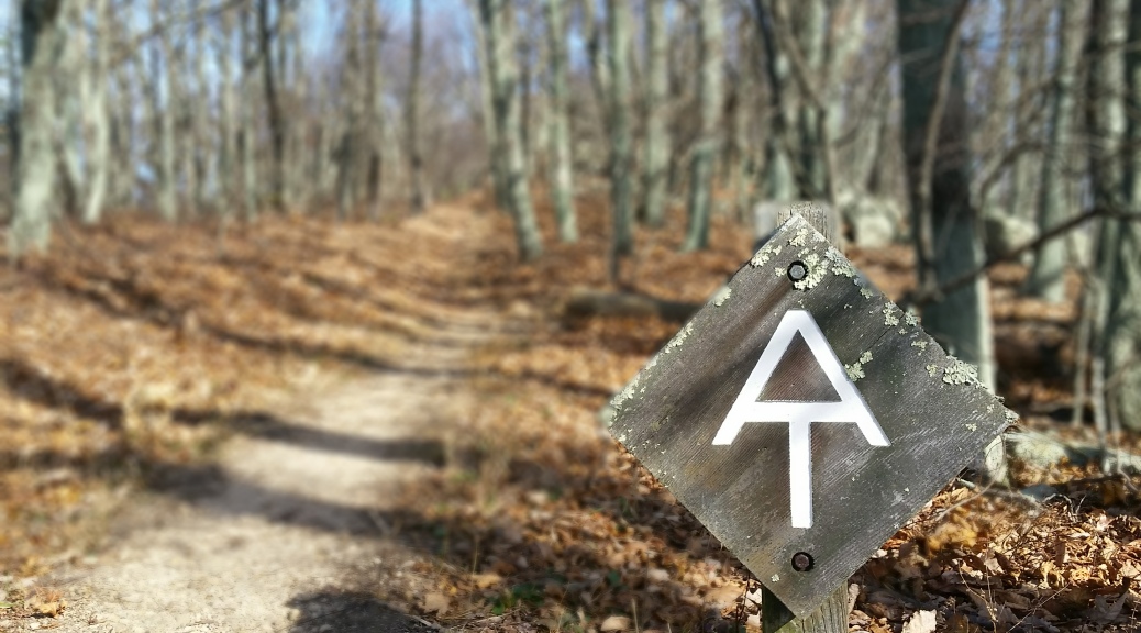
New Address: P.O. Box 1729 Flagstaff AZ 86002-1729
All the critical little things – PCT Gear
1) Headphones
Headphones can be a lifesaver out on the PCT (no brainer right?). Get a set that has a mic so you can call and walk at the sametime if need be. When are these bad boys crucial?
- Sleeping – Key item here, especially when there are 70 mph winds, or if you’re sleeping under the I-10 w a recurring 2 hour train schedule. I sleep trained myself by listening to the same 4 songs every night, within 5 mins sleeping like a baby. While hiking, I rocked just 1 earbud in at a time to keep my ear our for other hikers, cars, nature.
- Music/Audio Books – Keeps you going through the low energy times
- Calling home, to a hostel, or occasional pizza/beer delivery.


2) Micro USB to your phone model Converter
Surprisingly handy for swapping your phone w your other electronics for charging
- Instead of 2 seperate cables, bring an end adapter to fit your Micro USB end.


3) Leuko Tape

Ditch the duct tape for foot care, this stuff sticks for days even when wet.
- Foot care – cover warm spots before they are blisters, cover blisters to keep them from getting worse after you drain them
- Cuts – Cover up your cuts w Triple anti-bacterial, gause, and leuko!
- Holding things together


4) Needle, Thread, and Floss

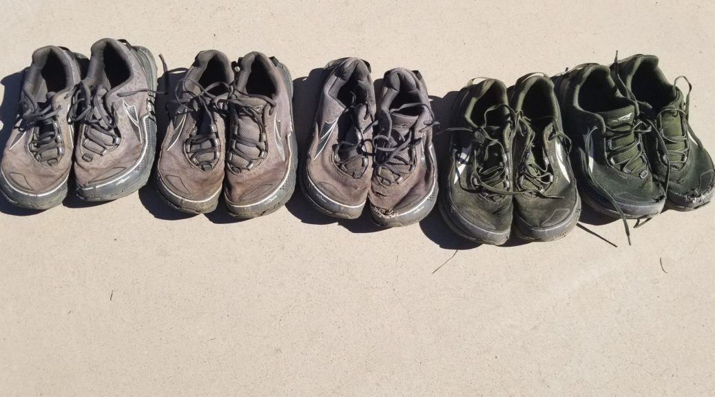
Talk about gear repair, this is essential to keeping you from getting shut down mid-hike. I blew out my Altras in the Sierras, but kept my shoes running with a little floss.
- Gear Repair – Sew just about anything up, pack, shirt, shoes, hat
- Shoe Repair – Won’t be a permanent fix, but it’ll keep you going!
- Clean them teethers, you’ll need that smile for your hitches!


5) A&D Ointment or Body Glide
Let’s face it, you’re going to chafe out there at some point. Be prepared! Chafing could turn from an irritant to an infection, to a real problem, so keep them cheeks greased!
- Anti-chafing


The key to Blogging on the Trail
I blogged every single night on the PCT. Alright, I admit I did miss a night or two. But more or less, for 147 days, I blogged for half an hour in my tent after everyone else around me was snoozing. The key to blogging on the trail is having the right tool!
The one item that allowed me to blog every night was a foldable wireless BlueTooth keyboard. I searched all over and settled on this gem that weighed a whopping 6oz. If you dropped the carrying case (that doubles as a phone stand) around it, you would get it down to 4oz.
I chose the first one below to use on the PCT for the weight and price point. I have included a couple other lightweight options that I found in my search.
This was a LIFESAVER and turned me from a T-Rex thumb pressing caveman, to a blog crushing efficient machine. So if you are considering blogging most days on the trail, consider this tool to change your game! Break free from the Thumb War!

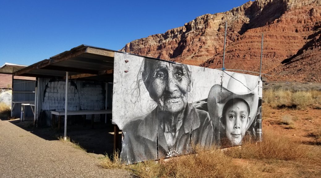
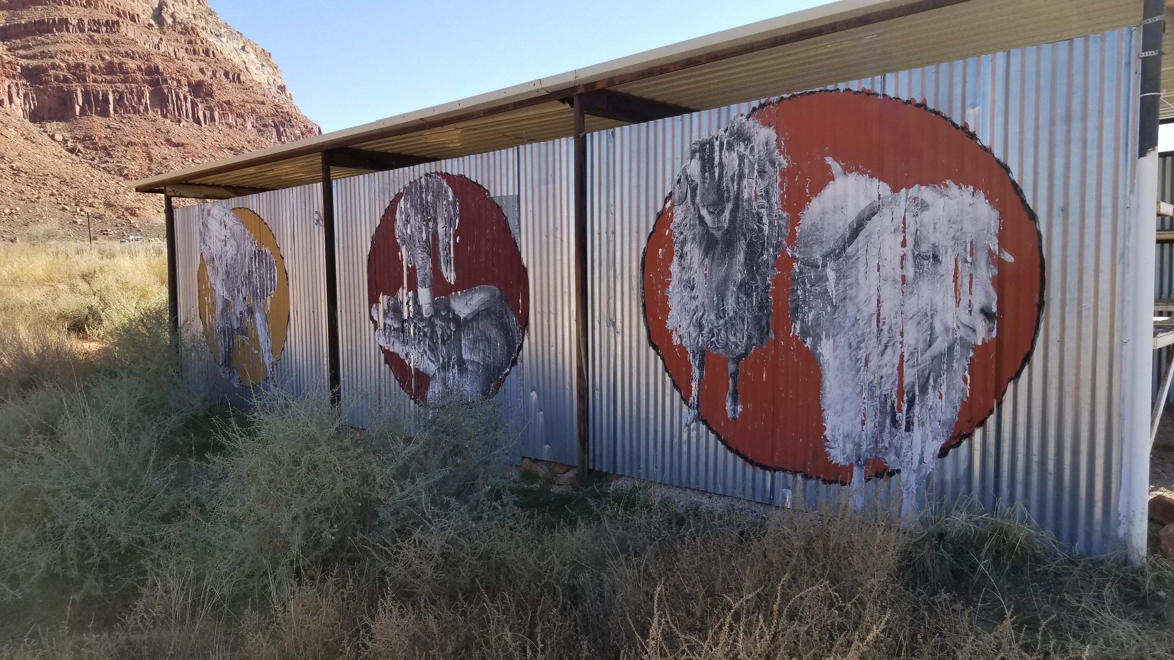
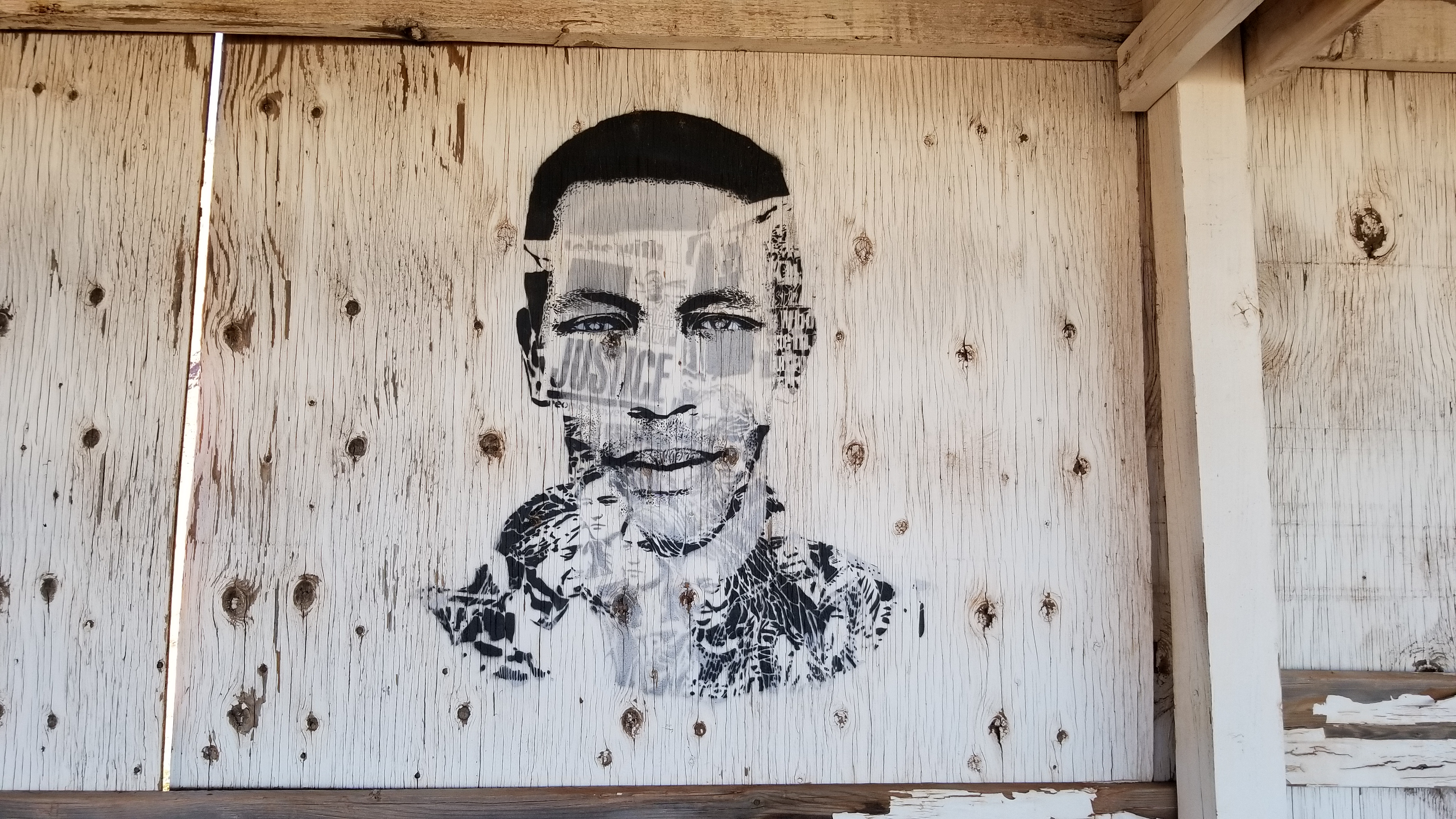
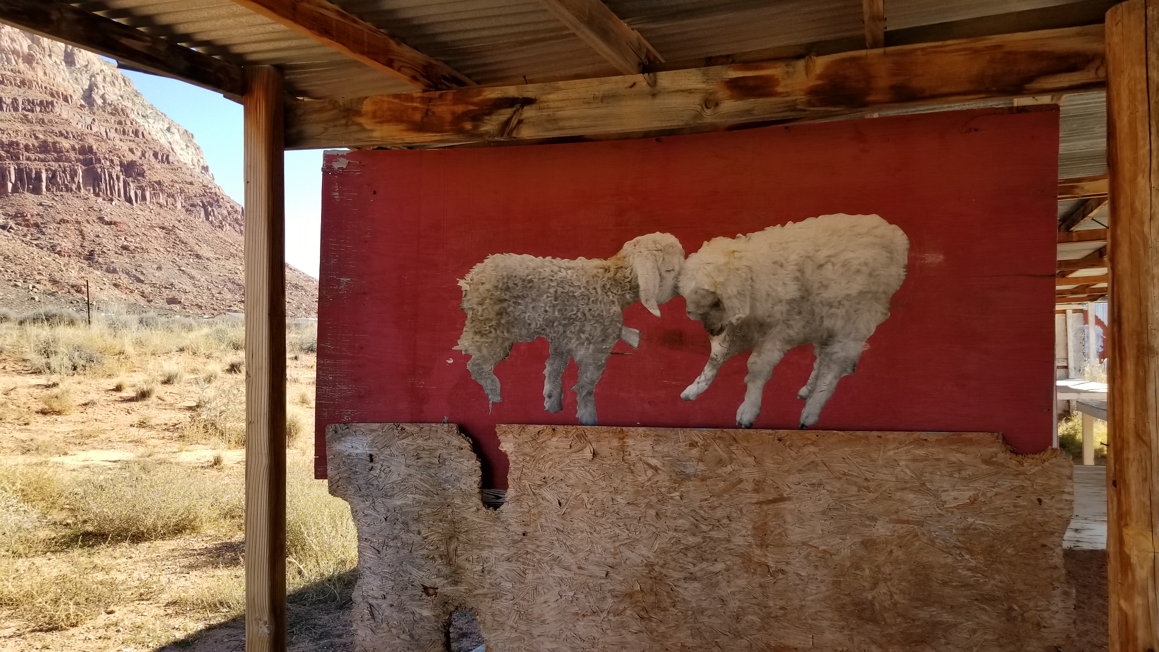
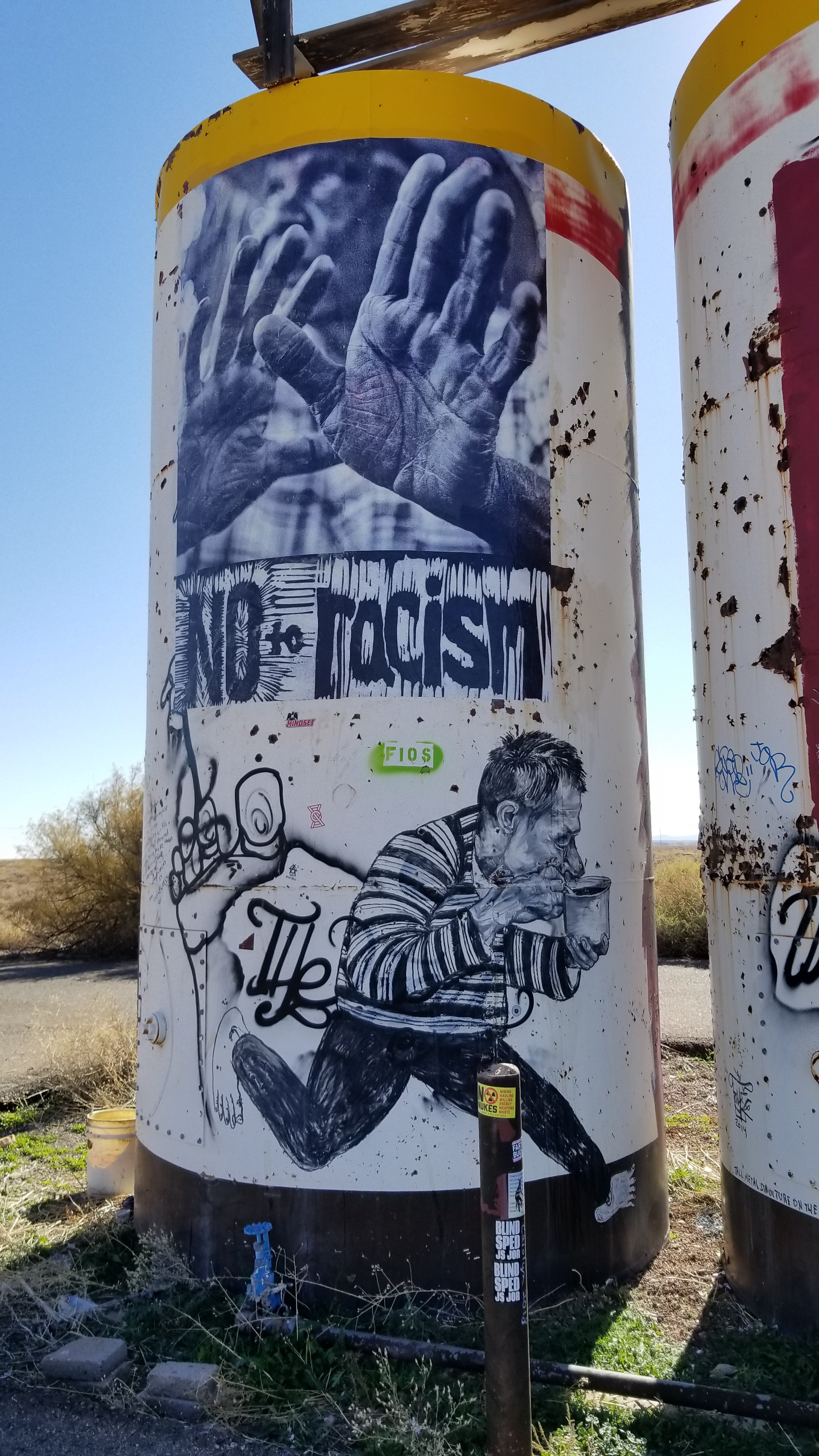
The Native American Banksy on Hwy 89
Making the drive from Phoenix, AZ to Southern Utah, it’s hard not to get lost in the gorgeous landscapes along the roadside. If you pay attention to more than the traffic and the magnificent rock, you’ll start to notice the Native American culture glimpse back at you.
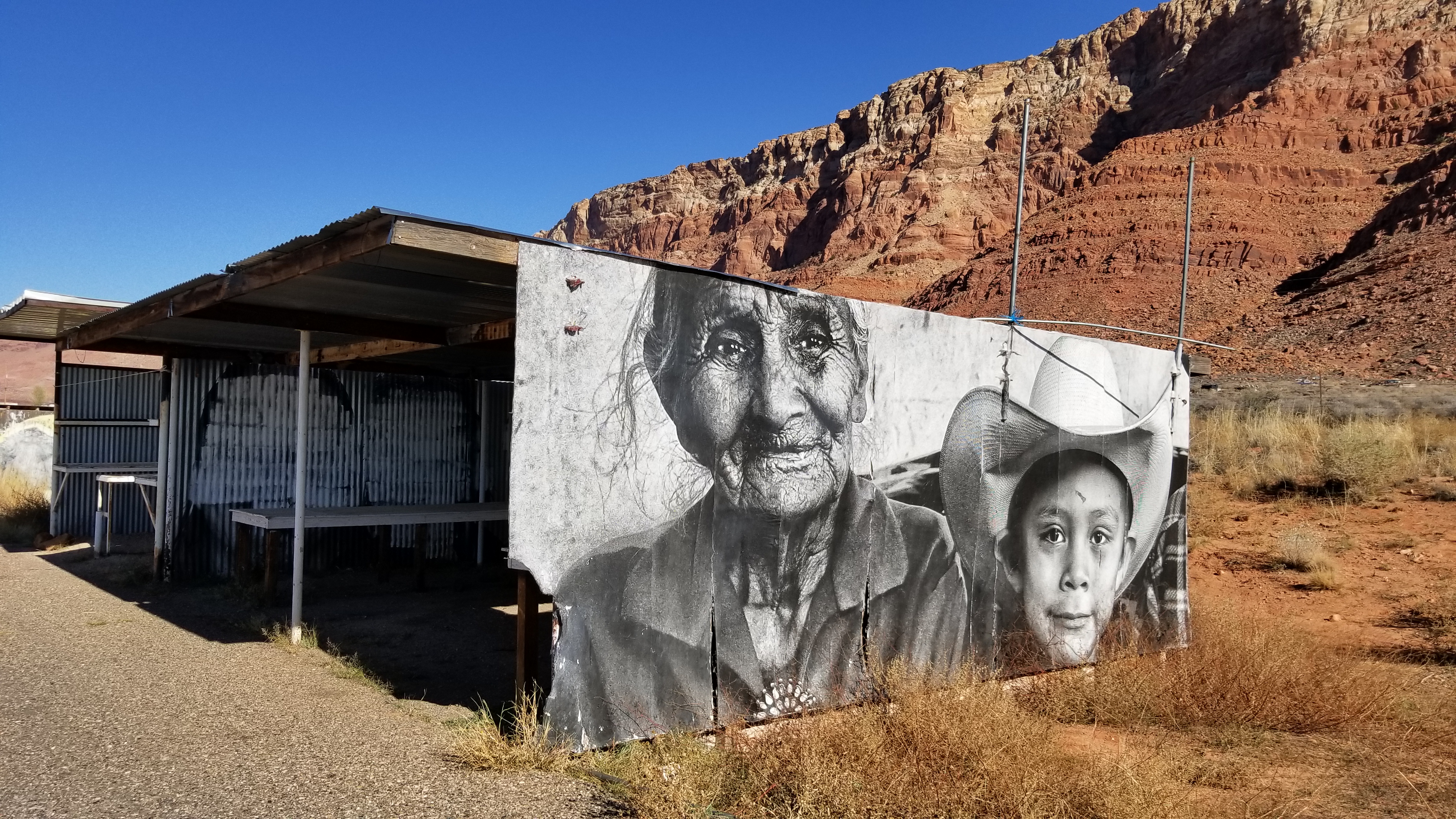
The deserted truck stops, empty jewelry stands, and long abandoned broken down roadside trailers. This is a shimmer of a dead dream, or the crumbs of a forgotten life. No matter how you look at Native Americans today, it’s a sad sight to see.
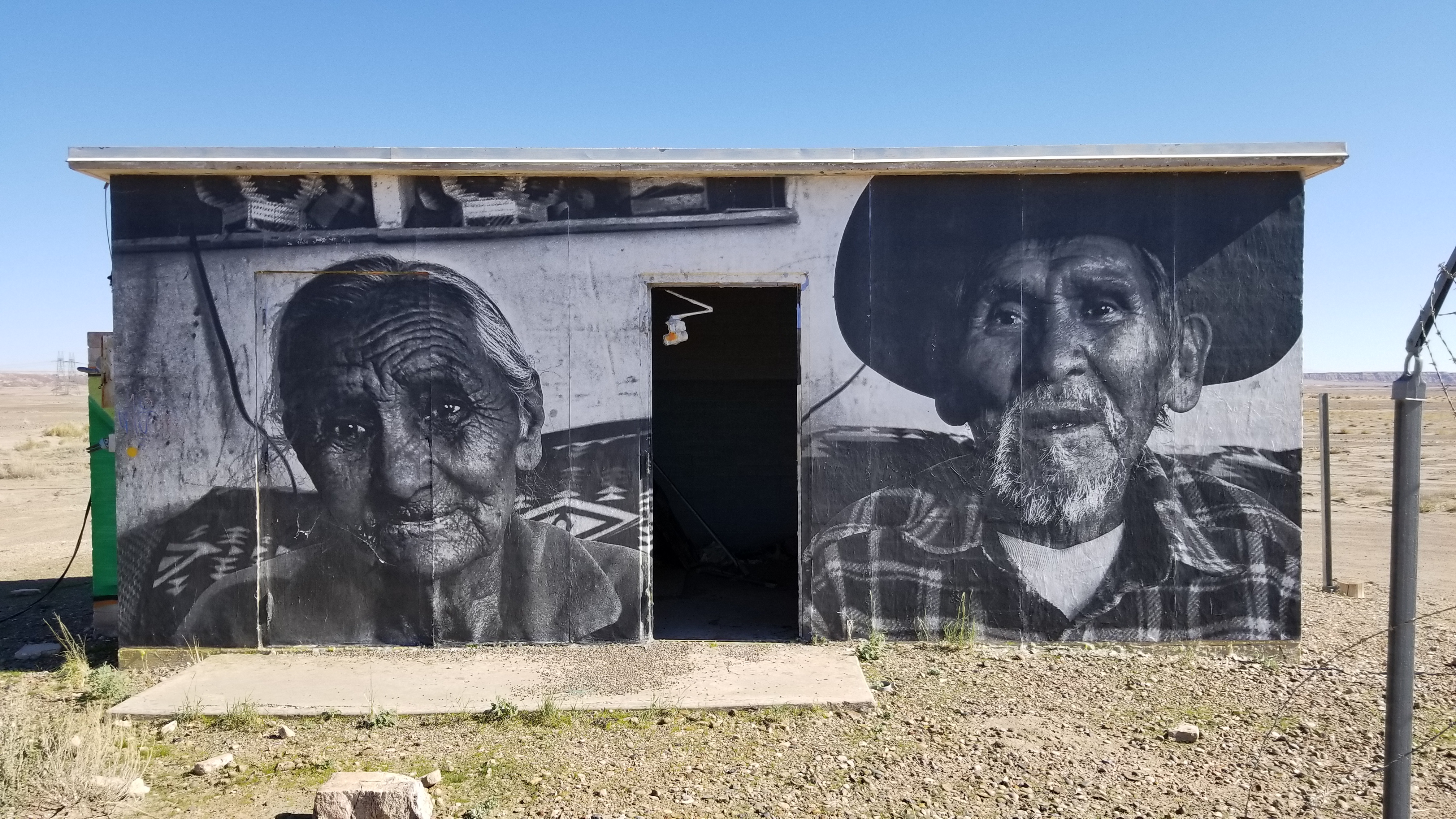
A people who were driven west, lost an all out war, and nearly eradicated to extinction. The meth epidemic, the diabetes, or alcoholism are continuing to diminish the remaining numbers.
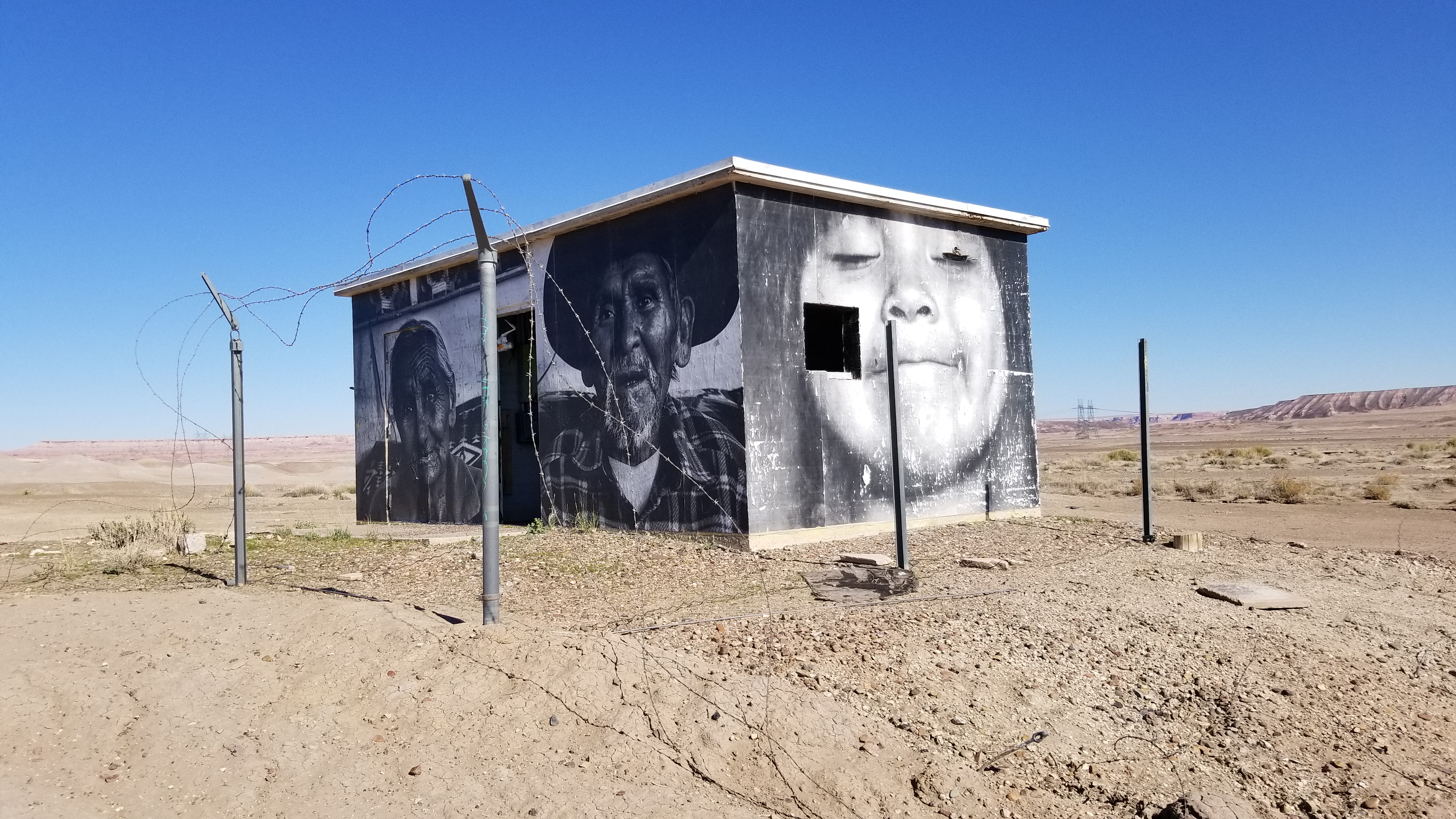
Someone out there is fed up, standing up, and making themselves heard, even if it’s from a faint cry of roadside graffiti. A stellar artist is wrapping abandoned houses and speaking from an isolated culture. Showing intimate images of family and friends in everyday settings, giving the passers by a glimpse into what Native American culture is.
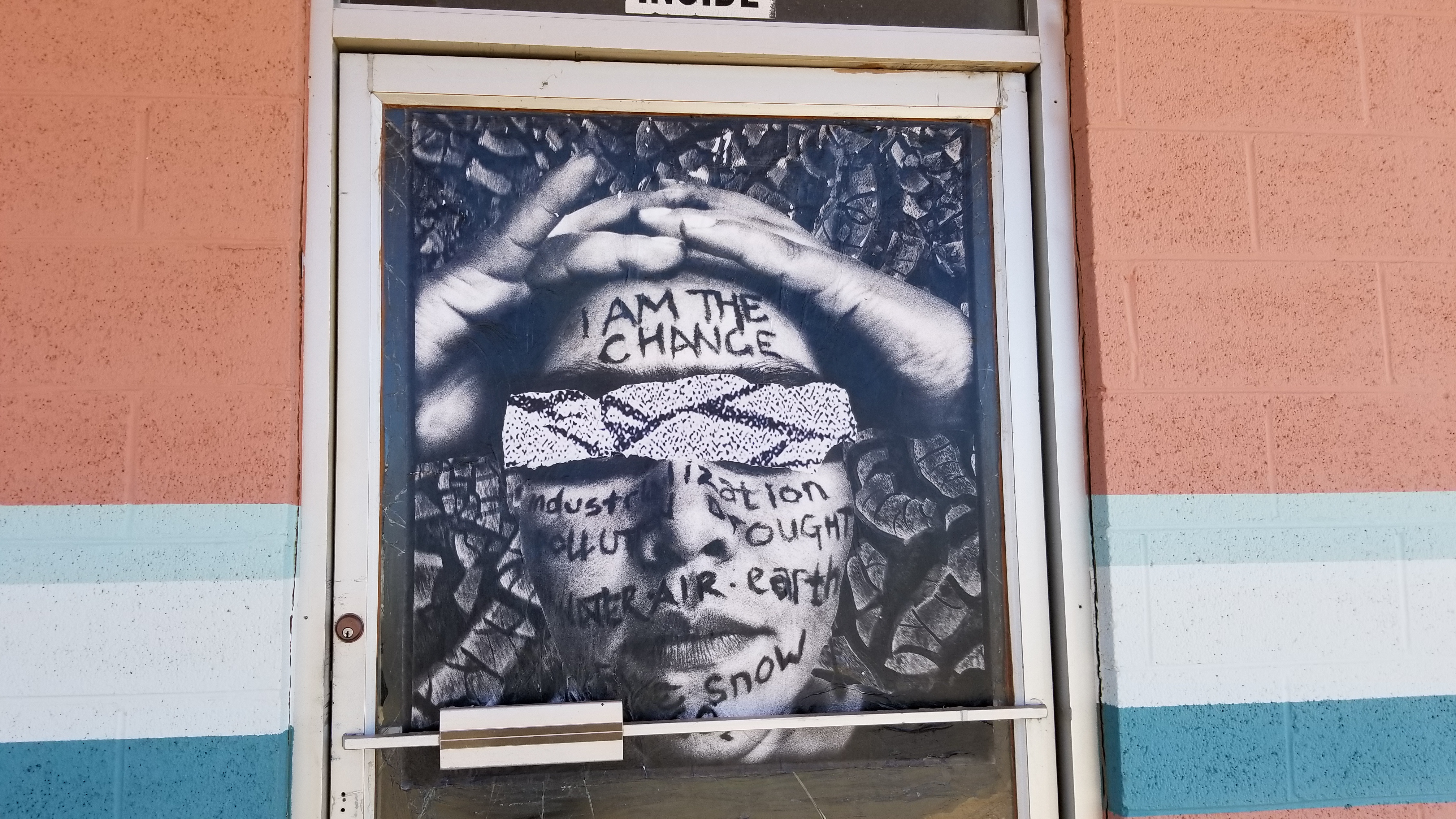
They are also pulling no punches against coal companies and uranium miners coming onto native lands and taking from the soil at what I can assume is on the same level of cheapness that it took for America to obtain the Louisiana purchase from the French . . .
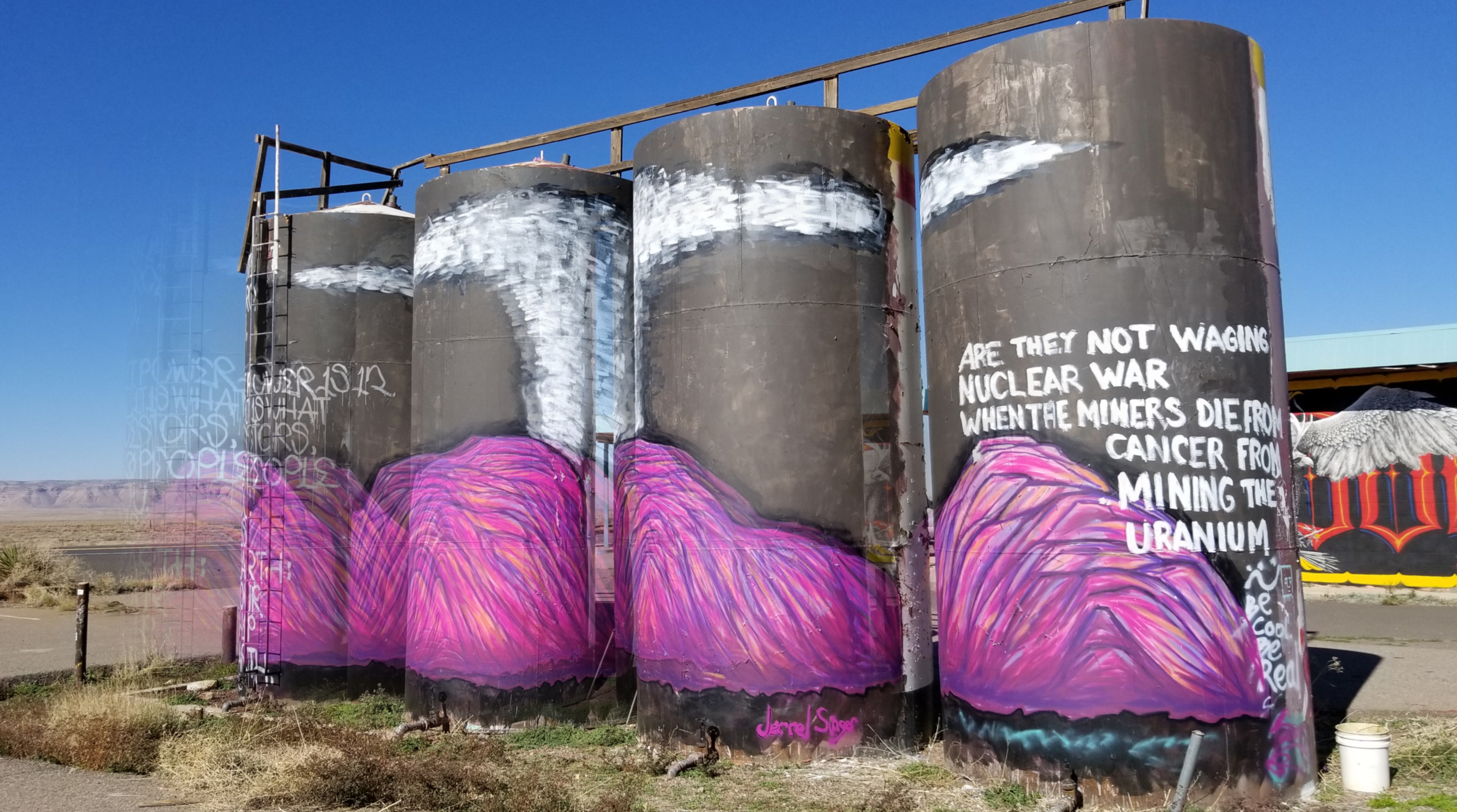
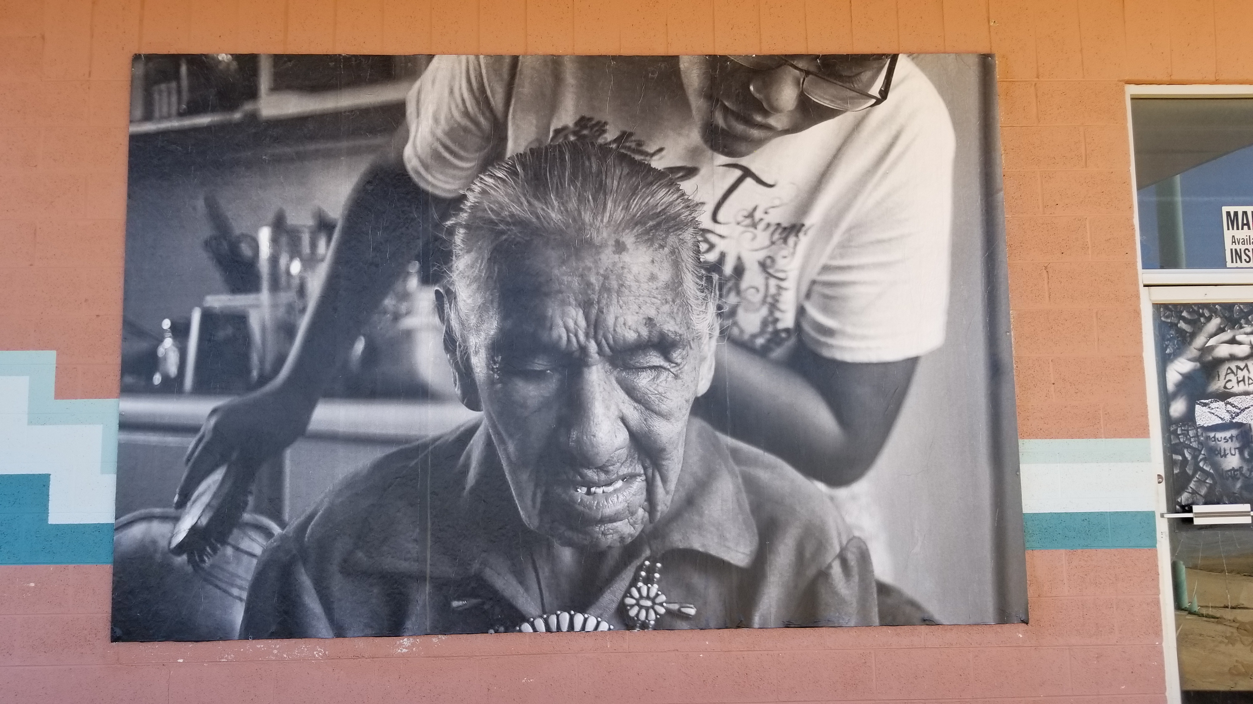
At any rate, the images are undeniably powerful. So the next time you’re cruising along with a soda in hand and your cigarette hanging out of your open window in this beautiful landscape, take a closer look. Some people are speaking, if you are willing to listen.
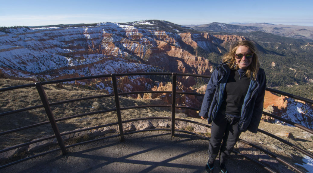
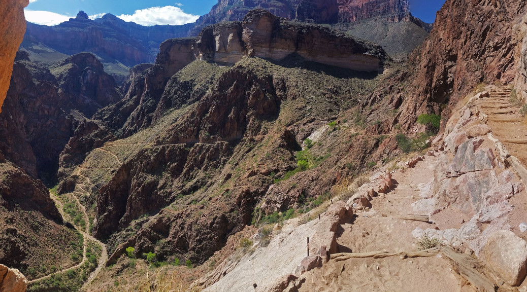
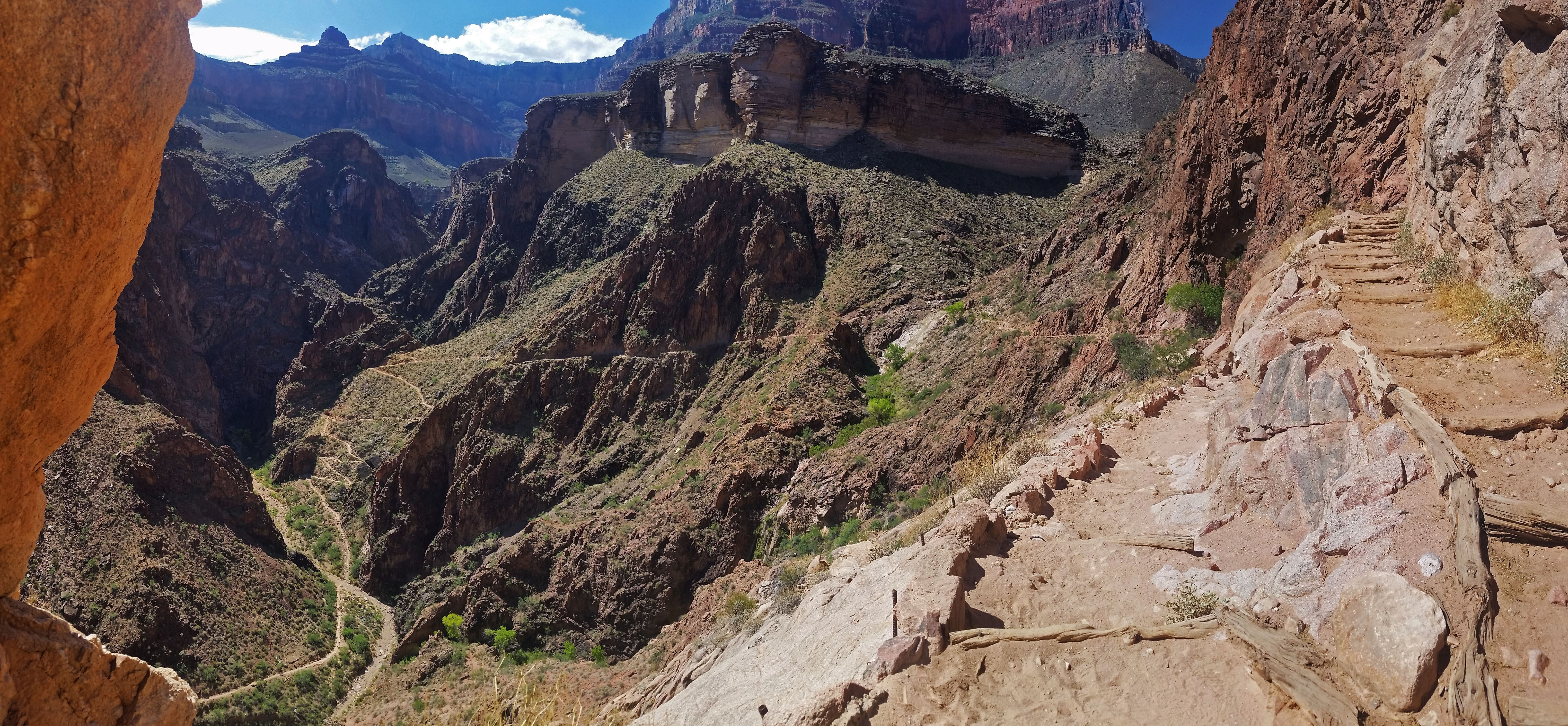
Cedar Breaks: Under-appreciated Utah Gem
Cedar Breaks: Under-appreciated Utah Gem
Coming to you from the: Explore Your Backyard Series
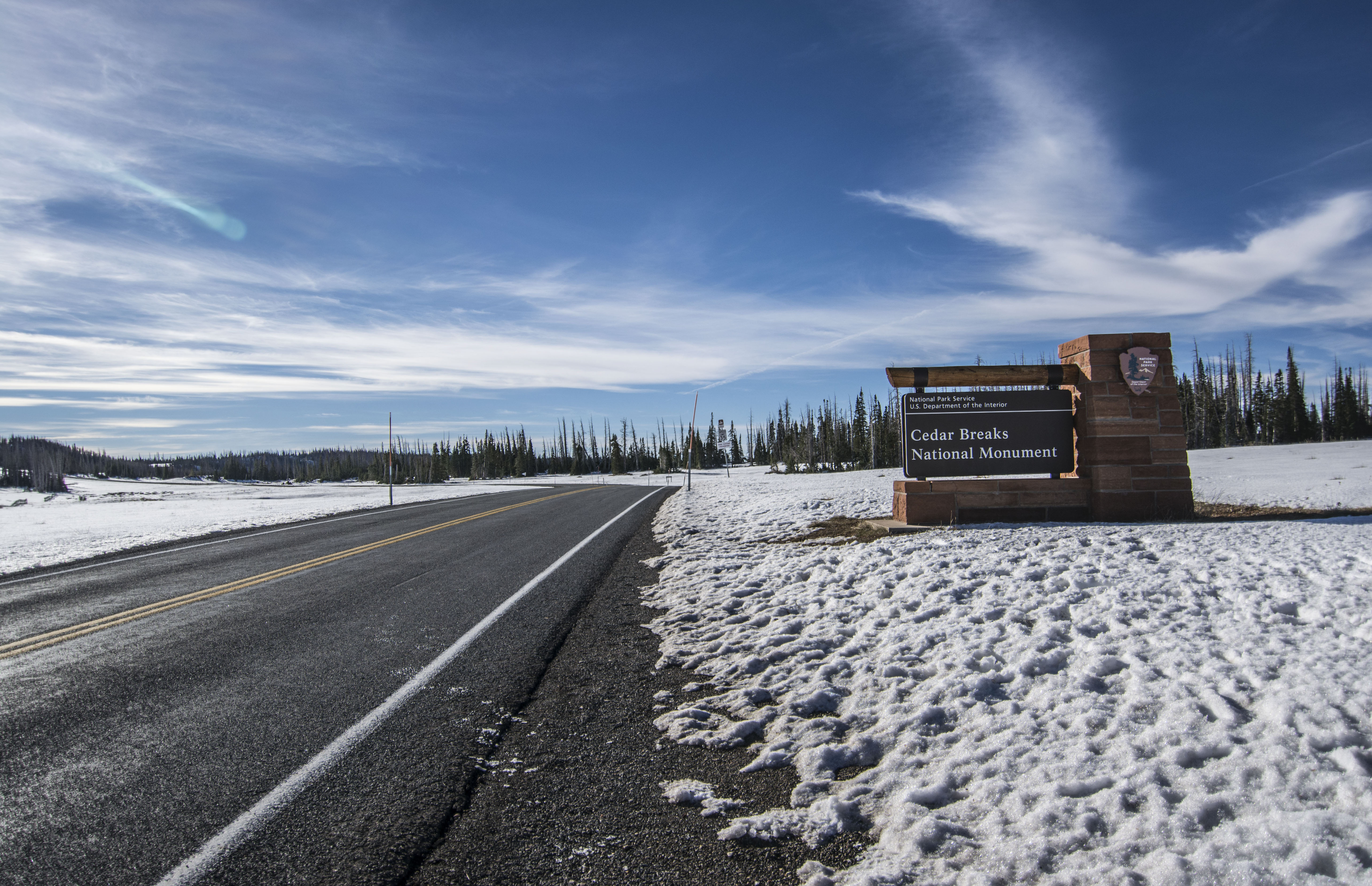
This past weekend Izzie and I drove up to Cedar Breaks National Historic Monument, which we refer to as the mini Bryce Canyon. It is a stellar place to visit! It had sick views and hoodoos to go all around. There are a few rim trails that are pretty easy. Unfortunately there are no legal trails that go through the heart of the National Monument. But don’t fret; there is a stellar circumference trail we discovered that can take you through some stunning diverse landscapes.
Trail: Rattlesnake Creek Trail to Potato Hollow Trail Loop.
- Length: Approx 22.2 miles round trip (with road walking)
- Other options: Shuttle Bike/Car at Blowhard Mountain or at bottom of Ashdown Gorge
- Elevation Delta: Max: 10,463 ft; Min: 7204 ft; Delta: 3,262 ft
- Total Elevation Gain: 5,031 accumulated gain
- GPX: Link
We woke early, to a snow covered plain at the Rattlesnake Trailhead and proceeded to dive right in. Immediately you enter the woods and can see faint views of Cedar Breaks through the trees. Take the quick off-trail side trip and snap some great pics of the park from the rim. The trail then dives down through the forest, through pines, aspen and open plains, into Rattlesnake Creek where you skirt a deep gorge and are finally spat into Ashdown Creek, the river that forms it. Take the sidetrek down the gorge, trust me, you won’t regret it!
 Snow on the ground . . . so glad I brought my trailrunners!!


 Beautiful Ashdown Gorge!


Once you’re done, tighten up those hiking boot laces and dig hard for the haul out from the bottom up Potato Hollow back up to the rim! Great views once again! Potato is definitely the less traveled of the two but still a beautiful trek. Haul back up through the shrubs, plains, aspen, and pines and pop out at two large communication spheres. From here you can walk the road back, or set up a car shuttle, drop a bike if you’re rockin solo, whatever your pleasure.
Had your fill of Cedar Breaks on Saturday but aren’t ready to go home?
The surrounding area is pretty sweet too. There are a ton of lava fields, lava tubes (caves) and lakes to explore! Apparently this area has a big snowmobiling community in the winter, but it’s still pretty great to explore on foot. We took the opportunity to check out the following caves and local hikes:
Lava Tubes:
Mammoth Cave: https://www.fs.usda.gov/detail/r4/learning/nature-science/?cid=fsbdev3_016108#hellsBackbone
This lava tube cave is really cool; bring some clothes you don’t mind getting dirty, a helmet, a headlamp and a strong sense of adventure! There are a bunch of different tunnels to choose from (some are closed off in the winter due to hibernating bats). I like taking a chamber as far as you can go to its terminus before turning around and trying the next path. It isn’t a huge cave (2,100 feet of passage, some of which is closed), but we had fun exploring and finding all the hidden entrances.

 Whats that?!


_1")


Bowers Cave: https://goo.gl/maps/DyNNjP7tt4D2
This guy is definitely less traveled, but is a really cool lava tube cave none less. It drops down with a wooden tree ladder to begin with and has 2 large rooms that you can stand in. Poke around, it’s a little wet, but really cool, plus we found a bat just chilling!
 Huh, wounder where this goes!


 Woot!
Woot!


Ice Cave: https://goo.gl/maps/rYNgFophwPp
This was the smallest of our finds and seemed like it was regularly frequented, still cool to see though.


Navajo Lake:
Cascade Falls: 2.4 miles round trip ~ headwaters of the Virgin River
Pretty chill hiking in the pines shows off the beautiful forest to the south and a few more Bryce like formation areas. Bright orange and white hoodoos poke out of the side of the mountain as if it were cut away like a multilayered cake. When we went there was no water flowing from the mouth of the entrance. However, this just gave us another opportunity to go caving! The limestone walls of the cavern that guides the headwaters of the Virgin River was certainly cool to see! It was a little wet, but well worth the effort!
 Flow meter for the Virgin's North Fork Headwaters


PCT Gear Planning by Section
Planning for weather can be a challenge, especially when you’re looking at a 5 month long journey on the PCT. To simplify this problem, I have broken the trail up into sections with a similar climate. Those sections are: The Desert, Sierra Mountains, Northern Cali/Oregon, and Washington. Each has their own climate and weather challenges.
Note: I hiked North Bound (NoBo) from mid-April (4.14.18) to early-September (9.7.18).
The Desert: Campo (mile 0) – Kennedy Meadows South (mile 709). Most people think it’s dry and hot. Depending on when you are hiking there, this can be true, however it can also be frigidly cold! The biggest concerns in this section are sun protection and finding water! It can get cold at night, especially early in the season (I saw a night with 19 degrees F on Mount Laguna on my 3rd day and it snowed on Mt San Jacinto). I saw 1 day of rain (2 hours total), and it only went below freezing at night twice.
- Leave at home: Snow Gear, Rain Pants, BearCan
- Bring with you: Rain Jacket (always carry just in case, can double as extra warm layer), Sun Protection – Hat, Sunscreen, Umbrella*, Solar Panel*, Extra Water Reservoirs (enough to carry 6 liters max)
PCT So-Cal Backpacking Gear List
The Sierras: Kennedy Meadows South (mile 702) – South Lake Tahoe (mile 1090). Welcome to the big mountains! You will be traveling at 10,000 ft on average for quite a while. The sun is still intense at high elevations so don’t send that hat home yet. The biggest concern in this section is going over the snow covered passes. Rule of thumb: June 1st is the earliest you should head north of Kennedy Meadows South. I had all my snow gear sent to me at Kennedy Meadows South plus some required food protection. Bear canisters are required between Kennedy Meadows South (mile 702) and Sonora Pass (mile 1017). The mosquitoes are SEVERELY horrible north of Tuolumne Meadows so bring a bug net (I just used my buff) and bug spray (I went without). Warning: DEET will eat your gear if you accidentally spill it on yourself. DEET is straight poison but there are alternatives to it (like Repel); this all a personal call. They finally let up a bit as you near Sonora Pass. I never saw rain, nights were below freezing only 3-4 times.
- Leave at home: Extra water reservoirs (only really need 2-4 liter capacity, water is abundant!)
- Bring with you: Rain Jacket (always have just in case, can double as extra warm layer), BearCan (required), Ice Axe, Microspikes, Rain Pants (wore these when it was really cold), Wool Beanie, Wool Gloves (it’s cold as crap in the mornings!), Bug Net*, Insect Repellent*
PCT Sierras Backpacking Gear List
Northern Cali + Oregon: South Lake Tahoe (mile 1090) – Cascade Locks (mile 2147). Congrats! You made it through the Sierras, now it’s time to plunge into the forest in Nor-Cal. Surprisingly the highest temperatures I saw on trail (in the 100s) were in Nor-Cali near Hat Creek Rim. People were so warm they sent their sleeping bags home and got quilts (I troopered through with my 1 bag cause it’s all I’ve got!). I sent home all my snow gear from South Lake Tahoe in my Bearcan (11$ as opposed to 25$ at North Kennedy Meadows). Bear canisters are required in Lassen Volcanic National Park (mile 1343-1363). You can avoid the Lassen requirement by hiking through the area in 1 day (it’s 20 miles and you’ll be cranking by mile 1343). You’ll start to get near forest fire season by this point. I fought the smoke by covering my face with a buff, others opted for the facemask (your choice). Oregon had more relaxed accumulated elevation gain so you’ll be cranking through the whole state of OR in just 2-3 weeks. Never saw rain, nights were only in the 30s once in Oregon at higher elevations.
- Leave at home: BearCan, Ice Axe, Microspikes, Rain Pants, Solar Panel (not enough light – tree coverage from forest hiking).
- Bring with you: Rain Jacket (always have just in case, can double as extra warm layer), Extra Water Reservoirs (4-5 liter capacity is good as there are some dry sections), Sun Protection – Hat, Sunscreen, Umbrella (for sun)*
PCT Nor-Cal + OR Backpacking Gear List
Washington: Cascade Locks (mile 2147) – Canadian Border (mile 2652). Bring on the rain! Now that you have crossed the Bridge of the Gods, it’s time to get used to big elevation gain again. Washington was true to its reputation, with rain and forest fires. Send yourself your rain pants again and be prepared to be wet. Hopefully the forest fires are dying down with the onset of rain but you’ll still have some trail closures, it’s just how it goes.
- Leave at home: BearCan, Ice Axe, Microspikes, Solar Panel (not enough light – tree coverage form forest hiking),
- Bring with you: Rain Jacket, Rain Pants, Reservoirs (2-4 liter capacity is all you’ll need), Umbrella (for rain)*
Good luck out there! The right gear can be the difference between an enjoyable trek and a miserable one!
*I never personally used the equipment with (*), however I saw many hikers on trail with it.
A Hikers Approach To Trail Running

I’m sure all of you have seen the minimal pack wearing, bright shiny shoes wearing, sport glasses and bandana having shirtless (a good portion of the time) trail runners galloping past most hikers on any given trail. By that opener, you could probably guess that I am no trail runner. I’m just not built for it, and I don’t have the love for it like some, but if challenged I will rise to the occasion.
Back in the spring, my buddy Rene invited me to a race called “Gaspin’ in the Aspen” up in Flagstaff, AZ, which will take place this weekend. Having plenty of time to prep, I accepted the invitation and signed up. As previously stated, I’m not a trail runner, but I’ll fill you in on a few secrets I’ve learned during the course of my short training period.
Secret 1: It takes only 3 skills to trail run: throttle control, obstacle tracking, and pushing through the pain!
Throttle Control – When I trail run, I try and keep a running pace going the entire time. When I hit a tough grade, I try to pull the throttle back as far as I can without actually slowing to a walk or hiking pace. It’s like climbing a hill in a “granny gear” (lowest gear) in your car… you may not be going fast, but you’re still making progress. With most people, even running in your “granny gear” is faster than a hiking pace in the long run. When you get to an easier grade or a downhill, you can open back up a little more or even crank her wide open.
Obstacle tracking – Keep a look out far ahead of you to know what the grade will be like and anticipate it. Use your energy efficiently and wisely, you don’t want to run wide open on a downhill if you have a steep ascent right after. At the same time, be sure to use your immediate scanning skills to make sure you don’t trip on a rock or root, or run yourself right off the trail to avoid an obstacle. Alternately scanning near and far constantly will keep you on your feet and knowing what is to come so you can keep your run going.

Push through the pain – You will get to a point where the grade seems to be too much to run it. Don’t give up! Keep pushing little by little, using your throttle control to ease the pace, and before you know it you’ll find yourself at the break. People are always underestimating their limits, and you’ll surprise yourself by digging deep and not backing down to the challenge!
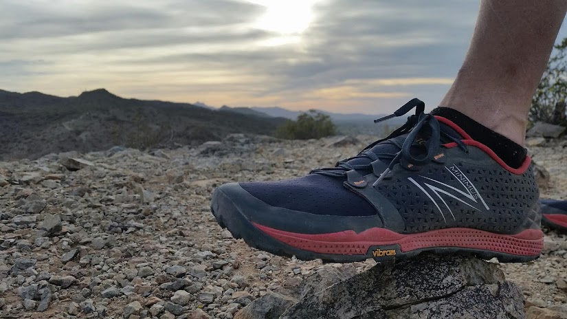
Secret 2: There is no special gear.
You don’t need magical $200 shoes, or a backpack made from space-age materials, or shorts bright enough to need sunglasses just to look at. Just throw on a hiking boot or regular ol’ running shoe, grab your raggedy backpack from high school, put on the shorts you just mowed the lawn in yesterday, and get out there and get after it. Sure there are the $200 shoes designed specifically for trail running, and they do help a little, but at the end of the day it’s not the shoe that makes a trail runner. It’s taking the first step off the couch and onto the trail that gets you there (granted you’ll probably new lighter gear down the line if you really love trail running).
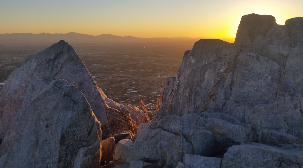
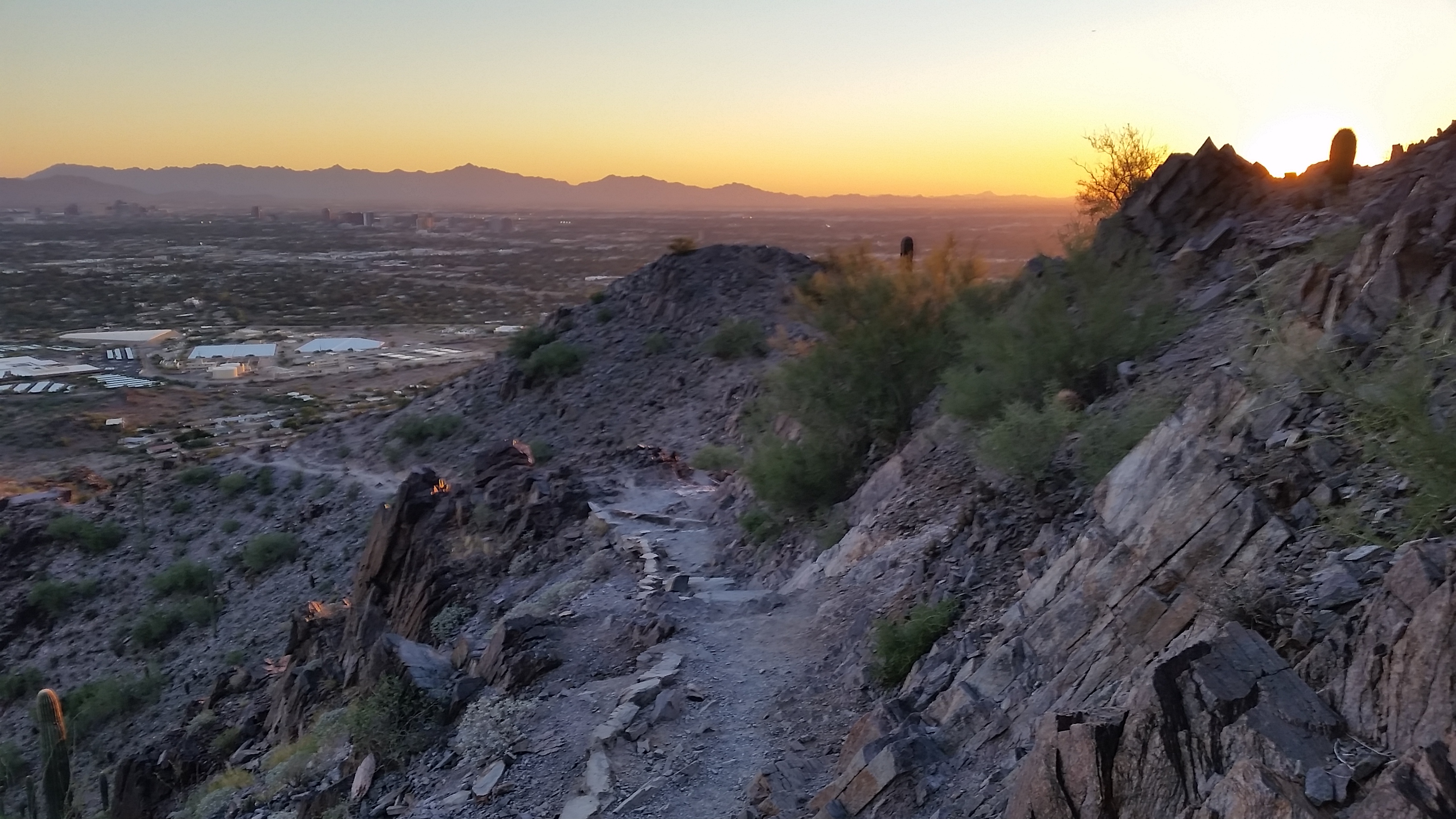
Just recently, I trekked up Camelback Mountain (Phoenix AZ), a pretty steep grade at 1000 feet altitude per mile, and put these a few of these secrets to the test. About ¾ of the way up in 105 degree heat I just plain ran out of steam and had to switch back to hiking. Nonetheless, throttling back and pushing through a few of the steeper parts really made all the difference in how I felt about the run overall. I never thought I’d make it even that far up the mountain running the entire way. Get out there and keep pushing the limits, you may surprise yourself!
Curiosity – The power that propels you
Curiosity is a funny thing. What’s over that’s ridge? What’s past that chute? What’s just around the bend in the trail? What can you see from the peak? A rustle of leaves just feet away behind a bush, a rattle from an unseen snake, a rock wall staring you in the face standing between you and a peak. What’s that? Can I make it? How far can I go?
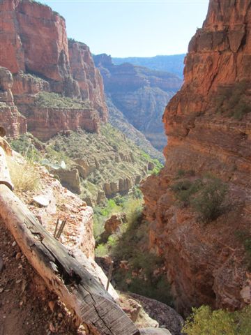
I remember looking at buttes in the Grand Canyon and thinking “I wonder if anyone has ever been up there.” I sometimes thought about what it would look like if you could paint the canyon with neon footsteps where humans have been since the canyon formed. It would be an awesome sight to see. How many people have stood where I have stood, touched the rocks I’ve touched, been the places I’ve been. Lastly, where has no one been, can I get there? The unknown; it’s the definition of adventure.
There is always something else to learn, always a new adventure to have. If you get to the end of your fulfillment in one medium/discipline you push to the next or find a new way to push the current medium/discipline to a new level. Find something new to try, hone your craft, become better, explore, share your experience. There are so many places to see, experience, and there is no reason for you to ever run out. If you find yourself complacent, take a step back, appreciate what you love, and re-evaluate what is important. Remember that no matter how hard you try you can never fully know everything there is to know, there is a beauty in that. So be curious, it is a power that can propel you.
Pain and Push – your Will can take you there
Suffering is something everyone talks about on the trail. There is a physical and mental limit to what you can push the human body. Everyone has their own limit, in every class of adventurer. Some people hit a mile and they can’t push further, some people hit 100 and are ready to go some more.
I have done some endurance related hiking in the past; pushes through long days, head lamp strapped on going into the night because the sun set and you’re still on the trail working. Starting before the sun is up to make sure to give yourself that chance to reach summit, or your target of the day.
I remember when I first started hiking I heard about people night hiking, I thought to myself, “that’s the stupidest thing ever!” I was only hiking a few miles at a time in the beginning. As I pushed into bigger and longer hikes it became apparent that attempting to accomplish 20+ miles days, at a hikers pace, one would be forced into the night. Headlamps became a necessity and it expanded my comfort zone. It’s funny how the mind can expand and the body adapt.
These bigger hikes, with big gain, sometimes into higher altitudes, made me realize that there were many of my own limits that were challenged and my comfort zone grew it many ways. On many treks I just remember feeling worked, miserable, stomach turning, unable to consume food. Physical limits had been met, red lining the whole way, gas tank on empty, mind going to places it’s never been, wanting to quite, give up, seeing things that weren’t there.
A lot of that goes away when you realize that the only person that can get you to the finish is yourself. No one can hike your hike for you; sometimes it’s a head down, grind on, one foot in front of the other push to finish. But even if you’re the only one that can get you out, its nice to have a friend trekking with you. Sharing the same pain, some of my best friends I have were made while out suffering together.
People have a fantasy in their head about trails, treks, and adventures; they idolize it in a way. I think many of those fantasies are born from the curiosity or the need to feel accomplishment of hitting the target and the memory of all the pain it took to get you there vanishes. No matter what the challenge, the cold, the distance, the difficulty, the pain, it’s the will that gets you there. Don’t give up, push a little further, you can make it, your will can take you there. See you all out there on the trail!
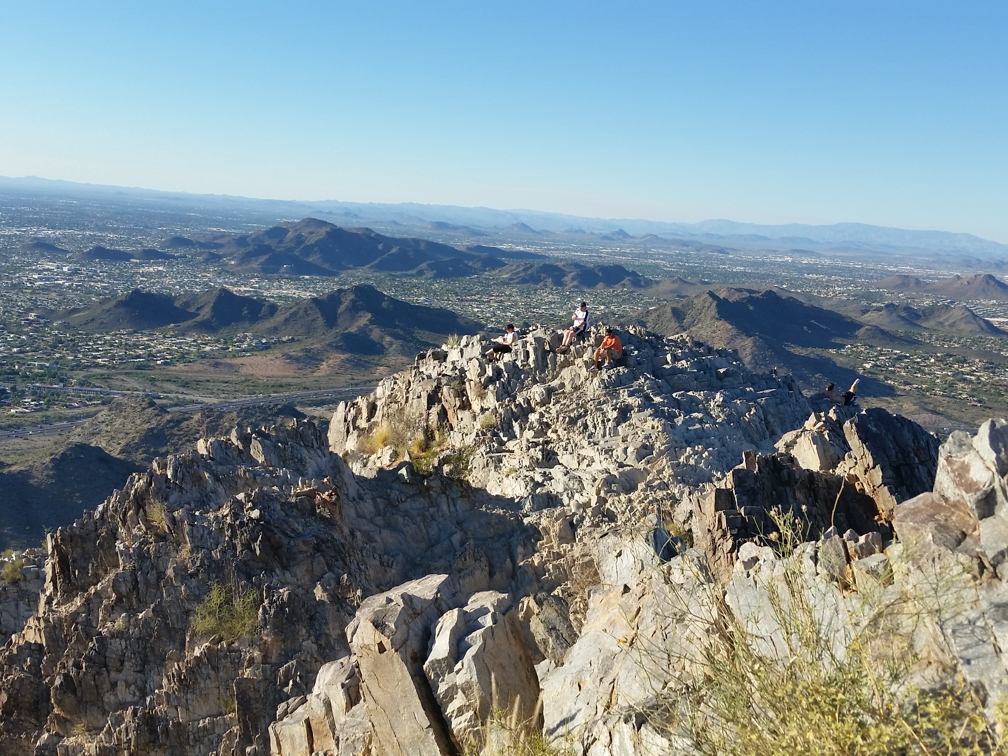
Squaw (Piestewa) Peak, Trail #300 – AZ (11.28.15)
Squaw (Piestewa) Peak is a great place to hike. It gets straight to work with its summit trail climbing 1100 feet in just 1.2 miles. If you’re a grinder and looking for good gain in short distance within the city limits, look no further.
The trail itself is much like the surrounding desert, rugged and tough. A years worth of trips to the peak will surely make quick work of any hiking boot you could throw at it. Sharp rocks jetting up reminiscent of Superman’s home world krypton create and line the trail to the summit.
I headed up the jagged trail with friends chilled from the 40 degree morning in shorts and a hoody. We quickly climbed hoping for sunrise to warm us, but the lazy autumn sun took its sweet time. We were all cold, but warmed as we pushed faster towards the top.
About one quarter the way up I placed my foot on a rock up push up and continue on, as I did my toe slipped from the rock face. With my hands in my hoody for warmth, I wasn’t much in the way of being able to catch myself. My left hip and soon my head slammed into the trail which was once beneath my feet. Startled by the swiftness of the fall, I jumped up and threw my hat back on my head and continued to push. The group all checked on me: Trail 1, Mike = 0. A little bloody, my bruised head reminded me to appreciate the trail and respect nature because it doesn’t always give hugs.
I love hiking, I love standing on a desert peak looking out across the expansive views of the southwest. Get outside, go explore, these aren’t the padded trails of the Northwest but they can be just as beautiful. See you on the trail!
HIKE INFO: http://hikearizona.com/decoder.php?ZTN=122
Monsoon on Squaw Peak – AZ (8.31.15)
I started hiking Squaw Peak (Piestewa Peak) just before sunset. As I started up I didn’t notice the Monsoon quickly rolling in from the east, my main focus was hitting the peak before summit. I hiked as fast as I could, focusing on the sun as it fell just beyond the mountains to the west. Minutes after the sun set I gained the peak. When I finally looked back to get a full view, I was taken back by what can only be described as one epic sky.
The wave of rain and dust from the monsoon rushed across the valley swallowing the light from the sunset like some hungry bottomless monster. What a sight! Lighting surged through the cloud on rapid fire like a brain firing neutrons, i knew it was time to roll! I bolted down the mountain in a hurry trying to reach my truck before the downpour reached me. Rain in the desert is a rare incredible event, one of the only times the desert gets its thirst quenched. The monsoon would give life to the once seemingly dead wildlife browned from the summer sun. Everything here has evolved to survive, adapt to such a harsh environment. Its truly incredible to see such a beautiful thing happen. Another awesome day on the mountain!!
HIKE INFO:
http://goatmanmike.com/2014/11/piestawa-peak-squaw-peak-11-10-14/
http://hikearizona.com/decoder.php?ZTN=122
South Mountain – Hidden Valley Figure Eight (5.7.15)
There is something about South Mountain Phoenix City Park that I just love. Just minutes from phoenix you can feel secluded, away from the hassle and bustle of the city, but still be close enough to peer back and appreciate whats in your back yard. South Mountain is the largest municipal city parks in the county, home to a ton of official trails, and plenty of un-official ones. South Mountain is a Choose Your Own Adventure best kept hiking secret in the Phoenix Valley. And I really dont mind it that way, get outside, live a little! Your mind and body will thank you.
Hike Info: http://hikearizona.com/gps=854
- Weather: Hi mid 80s, Low in the low 80s, bluebird skys
- Water: 0.5 liters
- Time: 2 hours
- Distance: 4.6 miles loop
- Accumulated Gain: 1,200 feet
